


Lachin corridor: a captive geography
08 February 2021

Tim Marshall, a British journalist and analyst on international politics and diplomacy, has two well-known books. One is “Prisoners of Geography”, and the other is “DIVIDED: Why We’re Living in an Age of Walls”. Both are bestsellers. In the first book, the author approaches the issue more in the context of geography. That is to say, he doesn't get involved in politics much. It just shows how much geography gives a state a political advantage.
The second book is about the walls that states build. The Israeli-Palestinian wall is an indicator of the conflict between the two sides. The "green zone" in Iraq acts as a guarantor of security but there is no sign of greenery: you will see nothing but large pieces of stone, barbed wire and debris thrown by the wind. India, on the other hand, has built a wall to prevent illegal migrants from Bangladesh.
In short, both are interesting books, find and read.
The last time I was in Qubadli was on October 29, 2020. On that date, I passed all the villages of Qubadli along the way, and finally stopped in Muradkhanli, looking at Lachin. This time I am in Lachin. It was so dangerous to stop in Muradkhanli three months ago, as Armenian army units were firing at the area from Lachin region. By february 2021, this threat has already been eliminated.
There is a bridge over one of the two roads from Muradkhanli to Lachin. At present, it is impossible to cross the bridge by car: it was blown up. Back in October, during a conversation with the military, they said that when Armenian soldiers withdrew, they would either blow up or mine all the bridges in the region.
We are going to Gulebird, the first village of Lachin region. We face the same problem on the bridge over the Hakari river. The villages of Gulebird and Safiyan were liberated by the Azerbaijani army in October, and it is not known whether the bridges were destroyed then or when Lachin was returned to Azerbaijan. In any case, we have to get out of the car and carefully cross the obstacle, reaching the village on foot. Here we see the same sad picture: destroyed houses, ruined places… In between, a steady building can be seen. The newest of them is a large hydroelectric power plant.
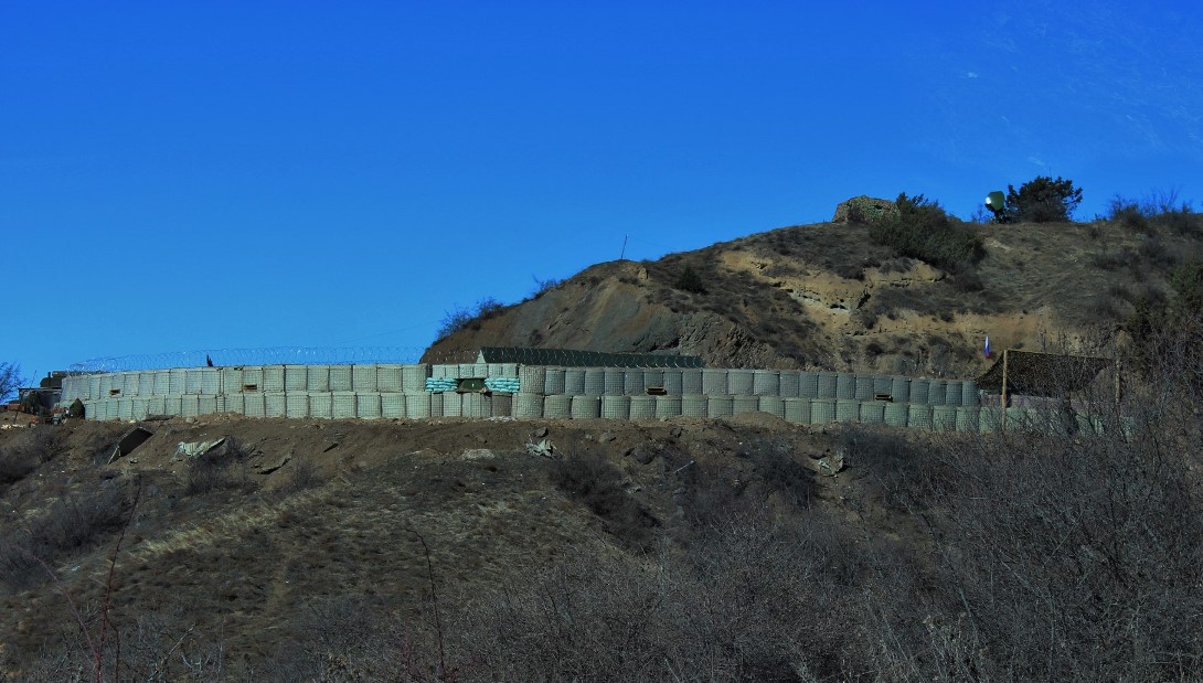
There is a 30-kilometer long road to the famous Lachin corridor. On the left side of the road is the Hakari River and on the right are steep cliffs. We see destroyed houses far away at the bottom of the mountains and another demolished bridge over the river. Then we climb a little higher. Armenia is already behind the mountains. Even from a distance, it is possible to see cars moving through Lachin. We are moving forward again, reaching the famous Lachin corridor. It is guarded by Russian soldiers.
According to the November 10 statement, the Lachin corridor (5 km wide), which will provide communication between Nagorno-Karabakh and Armenia, remains under the control of Russian peacekeepers. We return from the corridor, because official permission is required to pass through here.
There are two ways to avoid being a "prisoner of geography" and free Lachin from "corridor captivity": first, Russian peacekeepers must leave Azerbaijan. In the present case, this does not seem so realistic. Secondly, as stated in the November 10 statement, we must wait for the construction of a new route along the corridor connecting Nagorno-Karabakh and Armenia.


